
The Ann Arbor Neighborhood Network (A2N2) is a grassroots resident-led group connecting neighborhoods across the city. A2N2 is dedicated to building a more engaged community by sharing ideas, perspectives, and information in civic dialogue that can lead to thoughtful action for the public benefit.
Email a2n2contact@gmail.com to learn more.

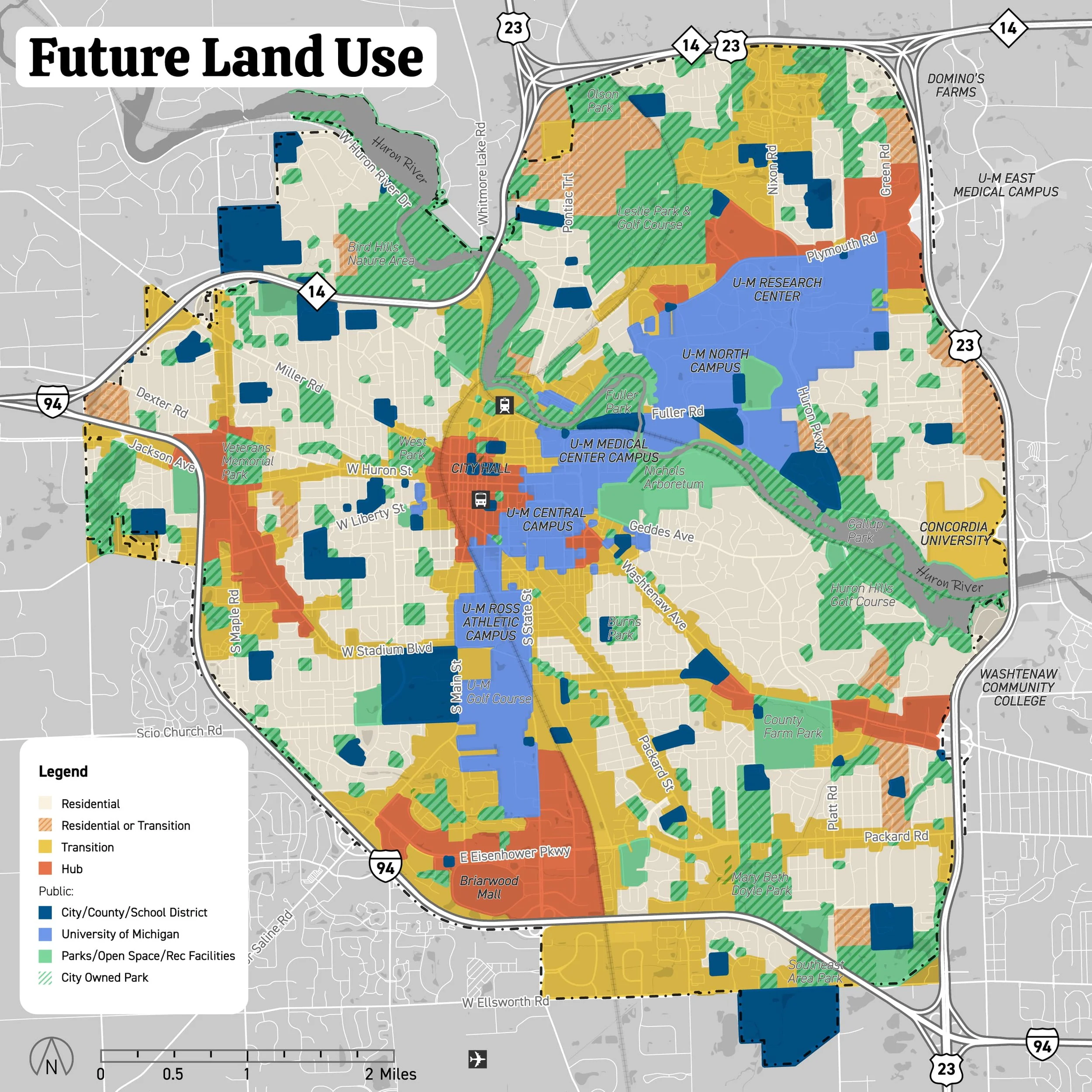
Explore the draft Future Land Use Map
Find your area and see how the Plan could reshape your neighborhood—and the city as a whole. The proposed map adds new districts that open the door to higher-density development across Ann Arbor. Yet key details about building height, bulk, and location, were removed from earlier drafts of the Comprehensive Land Use Plan and are missing—information residents need to understand before new zoning rules are written.
Take Action Now - Don’t Be Left Out!
Residents deserves a process that is transparent, data-driven, and genuinely reflects community values to
Protect vulnerable neighborhoods with affordable housing from predatory speculation and preserve stable neighborhoods with a strong, inclusive sense of community.
Advance genuine housing affordability, including a strategy for attainable, moderately-priced starter homes, stronger tenant protections, and limits on short-term rentals.
Protect natural features and green space.
Provide realistic planning data and cost estimates for managing, upgrading, and expanding water supply, stormwater, and treatment infrastructure.
Develop an equitable and efficient road system that balances all transportation modes while addressing congestion and actual usage patterns.
Honor meaningful public participation.
Democracy depends on all voices. It’s our City and it should be our Plan. Working together, Ann Arbor can get it right.

Share your comments with the City on the draft Plan!
Take a look at the draft Future Land Use Map to see how it could reshape your neighborhood. Then let City officials know what changes you believe are needed to the map and the Plan.
Submit your comments through the City’s feedback form by noon on Thursday, December 11.
Staff will share all submissions with the Planning Commission for its meeting on Tuesday, December 16 at 5:30pm.
Submit comments by Thursday Dec 11th Noon
Residents were left out from the beginning. In most cities, comprehensive planning starts with neighborhood-level meetings to shape a shared vision and set priorities. That never happened in Ann Arbor.
Join over 3,600 Ann Arbor residents who are urging the City to restart the Plan with real community participation.
Sign the Petition — Your Voice Matters!
No reservation needed! Share a 2-3 minute comment with the Planning Commission when they meet in the Council Chambers, 2nd floor, City Hall on Tuesday, December 16, 5:30pm.
A date has not yet been announced for the Commission’s special public hearing about the draft Plan, which is expected to take place in January or February.
Speak Out — Your Voice Matters!
City Planning Commission Meeting
Larcom City Hall, 301 E Huron St
Council Chambers, 2nd floor
Tuesday, December 16, 5:30pm.
Your donation helps fund yard signs, flyers, and outreach to keep residents informed, connected, and empowered.
Spread the word with a yard sign - no donation required!
Strong neighborhoods start with neighbors talking to neighbors. You can host a conversation with friends and neighbors–A2N2 provides support. Email a2n2contact@gmail.com.
Support a Stronger Community!
Democracy depends on all voices. It’s our City and it should be our Plan.
Working together, Ann Arbor can get it right.