

The Final Draft is here!
We’re at a critical moment. The Planning Commission has just received the final version of the Comprehensive Land Use Plan and it’s on the agenda for the Commission’s meeting this coming Tuesday, October 7, at 5:30pm. The Commission is expected to recommend adoption, sending it to City Council as the first step in moving it to final approval early next year.
A Comprehensive Plan should reflect the community's vision for how the city grows—guiding housing, transportation, services, land use, and the environment. A strong local democracy depends on hearing from all residents. Please take a moment to follow this link and complete a short poll on how well the draft Plan addresses the city’s needs and priorities. We would be grateful if you can share your views before the poll closes at 5:00pm, Monday, October 13.
A2N2 will collate and share responses with all poll participants, other Ann Arbor residents, and City Council and the Planning Commission.
Join over 3,500 Ann Arbor residents in demanding the city suspend work until these issues are addressed and robust public engagement has taken place.¹²
Petition Progress
⭐⭐⭐⭐ 3600 of 2500 signatures

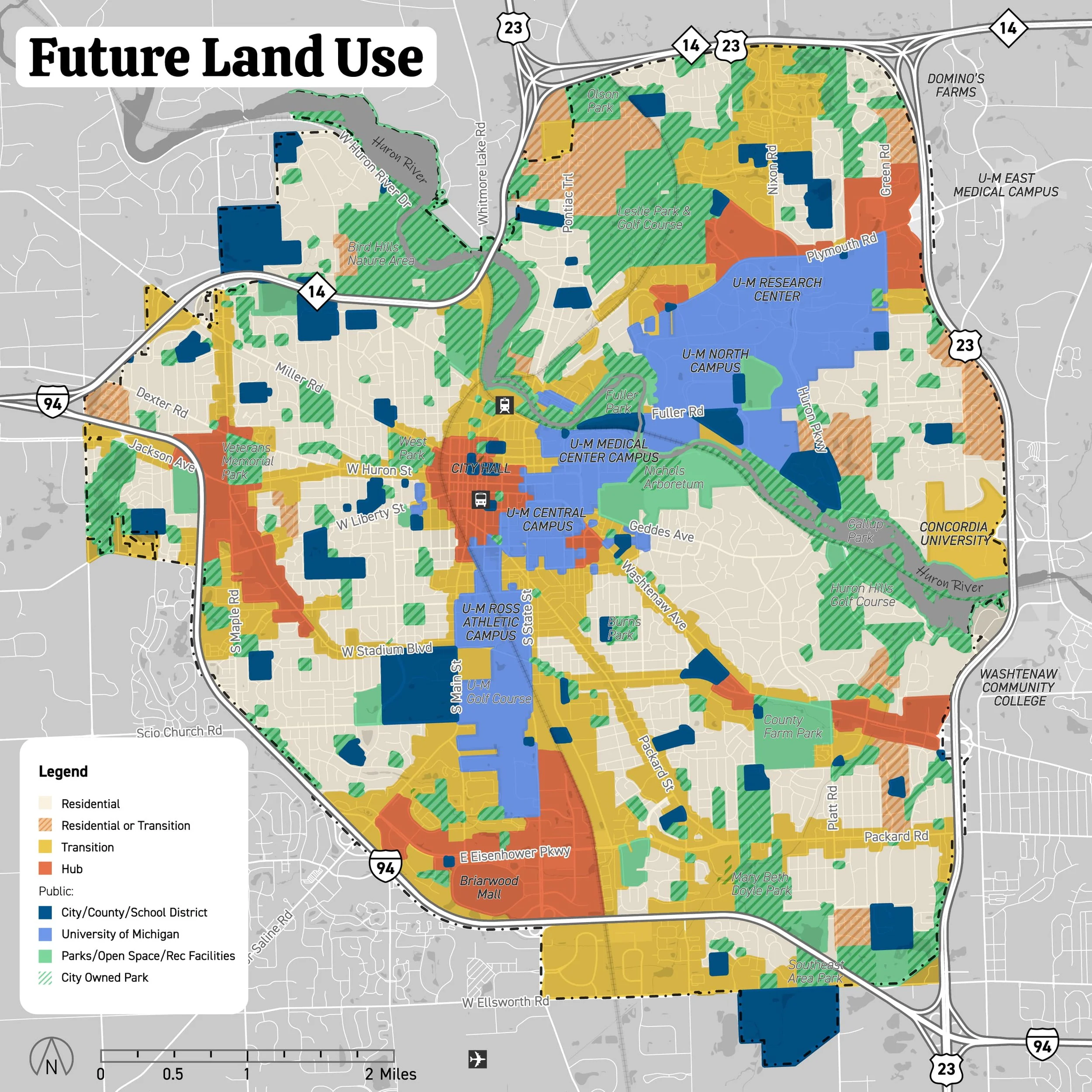
🗺️ Final Draft: Future Land Use Map
The “final” draft map is here! And, we have a high quality PDF version that allows you to zoom way in and see exactly what’s being proposed for your neighborhood:
Mapped: Every Acre The City Deleted📍
The interactive map below reveals exactly which parkland the City excluded from BOTH Draft Comprehensive Plans. Using official City of Ann Arbor GIS data combined with Trust for Public Land's manipulated database, we've mapped what's really at stake:
🟢 = Parkland in the Plan 🟡 = Parkland Missing in the Plan 🏠 🏬 = “Build a Lot!” Sites in the Plan
*Custom Google Map with A2 City GIS Data, Trust for Public Land GIS Data, and A2 Comprehensive Plan public engagement events and online activities, City of Ann Arbor GIS.
Notice how the missing parkland (in yellow) clusters around prime development areas? That's not a coincidence. The two large yellow areas are Leslie Park Golf Course (southwest) and Huron Hills Golf Course (northeast)—exactly what Council members called "terrible land use."

The City’s Plan:
Use Walk Score to Price Out Residents
What to know: The City's draft plan relies heavily on Walk Score—a metric owned by real estate giant Redfin that's designed to boost property values. New research shows Walk Score correlates with whiter, wealthier neighborhoods and actively contributes to gentrification. By prioritizing this biased metric, the City is essentially using a tool that values proximity to coffee shops and boutiques over actual community needs.
Why it matters: Walk Score isn't neutral—it's a real estate marketing tool that drives up housing costs. Properties with high Walk Scores see price premiums of 23-24%, making neighborhoods unaffordable for current residents. The metric ignores factors like cultural institutions, community centers, and services that matter to working families. When the City bases planning decisions on Walk Score, they're choosing displacement over genuine walkability. (Plantizen) (Streetsblog USA)
🔮 A2 Vacancy Rates: The Real Numbers
The City of Ann Arbor's Draft Comprehensive Plan relies on vacancy data from 2022, which does not reflect the most current market conditions. More recent data from multiple sources, including CoStar Real Estate Information (May 2025), the U.S. Census Bureau's American Community Survey (ACS) for 2023, and SEMCOG (July 2024 estimates), indicate significantly higher rental vacancy rates than those cited plan:

Specifically, the Draft Comprehensive Plan states on page 48: "Current vacancy rates are extremely low, creating an unhealthy balance between supply and demand: owner vacancy is 1.1% and renter vacancy is 3.1%."
However, May 2025 CoStar data show a market-rate rental vacancy of 6.9%, a figure that falls within the 5-8% range often considered indicative of a "healthy" housing market, a definition acknowledged within the Draft Comprehensive Plan itself.
Market Rate Units: 6.9% vacancy (23,664 total; 1,633 vacant)
Student Housing Units: 5.3% vacancy (11,913 total; 631 vacant)
Total Vacant Units and Beds: 6,018 (including student + market-rate)
The selective use of older data misrepresents current housing availability, directly misinforms residents, creates a skewed public engagement process, and undermines public trust. The Draft Comprehensive Plan must be updated to incorporate the latest available data to ensure an accurate foundation for future planning and development strategies.
📺 Plotzed Planners!
📺 Plotzed Planners!


📢 Make your voice heard by contacting the A2 City Council and Planning Commission - Demand they Pause the Plan!
Contact an individual Ann Arbor City Council Member, or all:
🎧 Hear The Deep Dives
〰️
🎧 Hear The Deep Dives 〰️


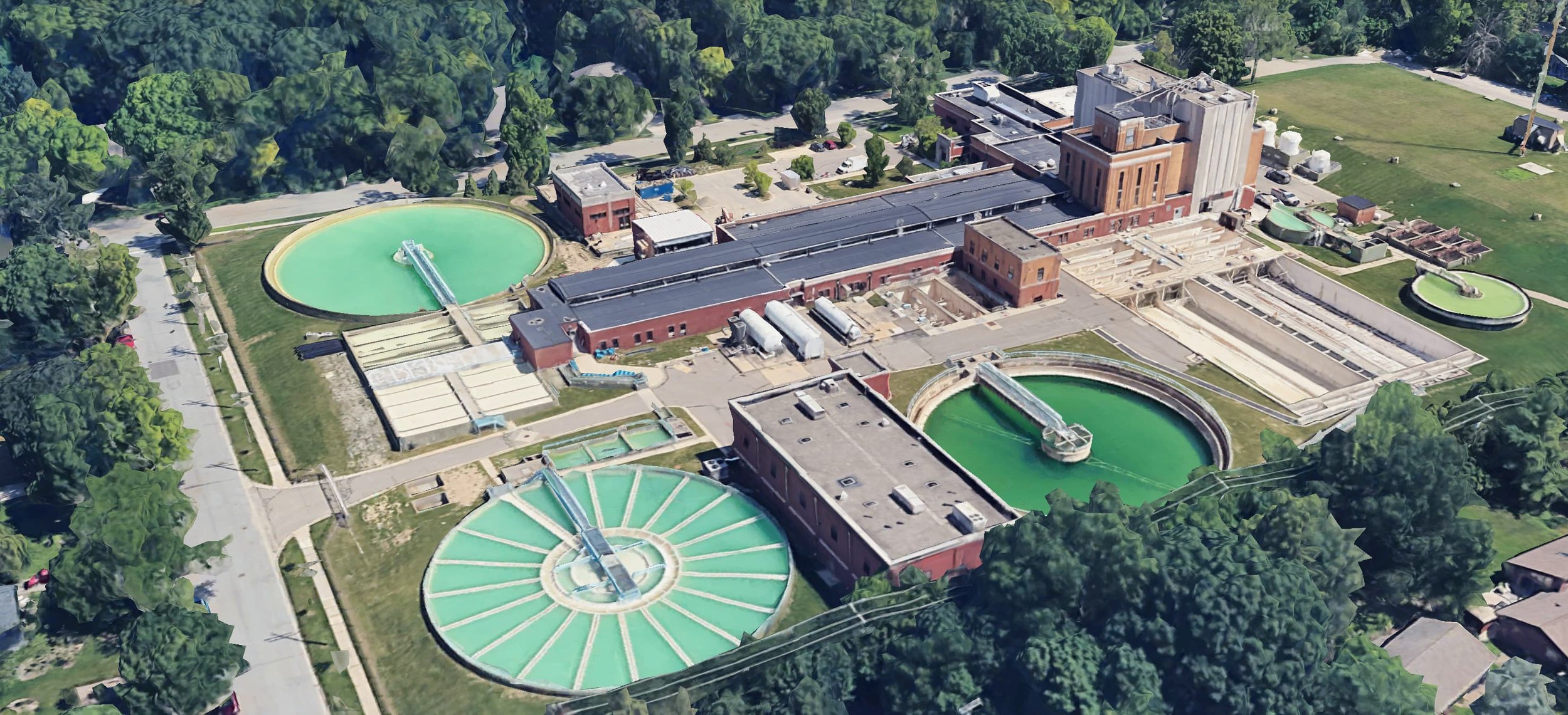
🎁 Bonus Memo!
Water and Wastewater Plant Capacity Evaluation (Rel. 5/6/25)
“The City would need to develop a new approach to delivering additional drinking water capacity to meet the projected build-out.
Previously, as part of the City’s 2024 Water Facility Plan, the City utilized long-term growth projections developed by the Southeast Michigan Council of Governments (SEMCOG), the regional planning body, which resulted in the determination that the existing plant capacity was sufficient for a 50-year horizon. A 50-year horizon is typically used for planning major WTP projects, which can require a decade or more to develop.
The City is already in the process of planning for replacement of the oldest portion of the WTP. The pace of anticipated build-out considered under the Draft Comprehensive Land Use Plan would alter the current planning process so as to avoid constructing components that would be undersized before the plant construction is complete.”
-OHM Advisors (City Consultants)
Ann Arbor officials are using two different methods to count city parkland – and the difference could cost you your parks and public land.
The official Parks and Recreation Open Space Plan (PROPs) counts ALL 2,210 acres, including golf courses.
The new Draft Comprehensive Land Use Plan uses a different method counting only 1,720 acres, conveniently excluding golf courses.
By reclassifying current parkland as "not parkland," officials could potentially bypass your right to vote on their future.
What you should know: Ann Arbor officials are using two different methods to count city parkland – and the difference could cost you your parks and public land.
The official Parks and Recreation Open Space Plan (PROPs) counts ALL 2,210 acres (17.96 acres/1,000 residents), including Leslie Park and Huron Hills golf courses.
But the new Draft Comprehensive Land Use Plan uses a different method counting only 1,720 acres (13.9 acres/1,000 residents), conveniently excluding golf courses.
Why does this matter? Our City Charter requires voter approval to sell parkland. By reclassifying current parkland as "not parkland," officials could potentially bypass your right to vote on their future.
Several council members have openly advocated converting the golf courses to developments despite:
Recent data showing Ann Arbor's population is actually declining by ~1.5%
The CLUP projecting 30,000-45,000 new housing units (600% - 900% higher than SEMCOG forecasts) with no data source provided • No budget for replacing the courses' critical flood control functions ($30-40M)
Loss of affordable recreation in neighborhoods where 21% lack cars
The same officials who reject modest EV charging for golf carts as "contrary to everything we stand for"support development that would eliminate 149 acres of tree canopy and require massive carbon-intensive infrastructure.