

The City’s Plan:
Use Fake Data to Sell Real Parks
What to know: The City replaced its official parkland count (17.96 acres per 1,000 residents) with Trust for Public Land data the City purposely never updated—omitting 484 acres, including both municipal golf courses and numerous nature areas. This switch produced a lower parkland count (13.9 acres per 1,000 residents), and recharacterized parks as "underutilized public land."
Why it matters: Both drafts of the Comprehensive Plan and the City's previous public engagement activities featured the false 13.9 acre ratio as fact. Now the Plan directs officials to do exactly what Council members demanded: convert golf courses they called "terrible land use" into "opportunity zones," using fabricated data to bypass our City's Charter-mandated approval rights.
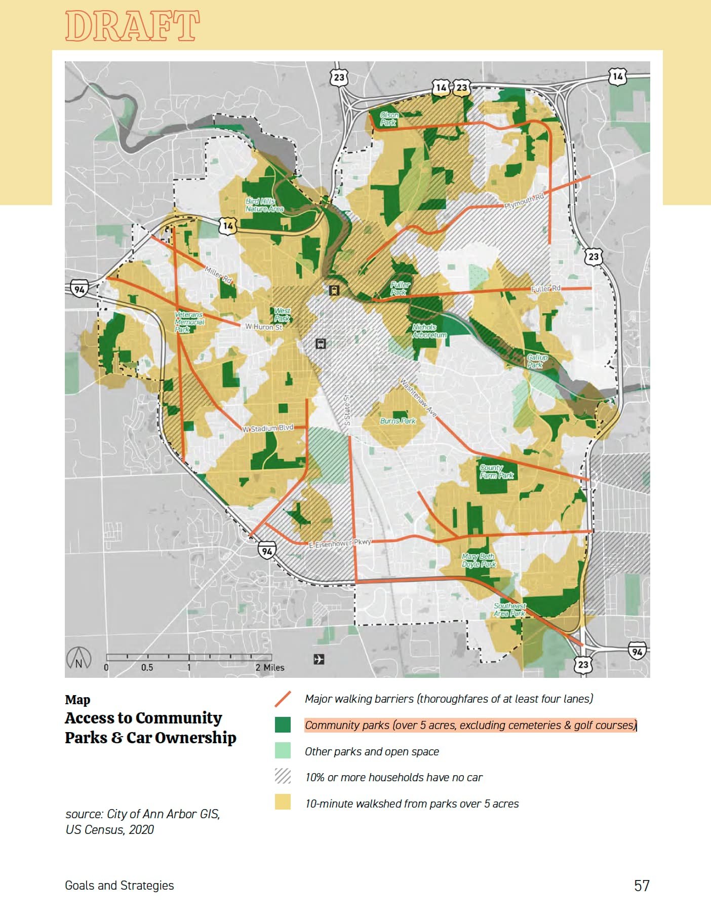
Mapped: Every Acre The City Deleted📍
The interactive map below reveals exactly which parkland the City excluded from BOTH Draft Comprehensive Plans. Using official City of Ann Arbor GIS data combined with Trust for Public Land's manipulated database, we've mapped what's really at stake:
🟢 = Parkland in the Plan 🟡 = Parkland Missing in the Plan 🏠 🏬 = “Build a Lot!” Sites in the Plan
*Custom Google Map with A2 City GIS Data, Trust for Public Land GIS Data, and A2 Comprehensive Plan public engagement events and online activities, City of Ann Arbor GIS.
Notice how the missing parkland (in yellow) clusters around prime development areas? That's not a coincidence. The two large yellow areas are Leslie Park Golf Course (southwest) and Huron Hills Golf Course (northeast)—exactly what Council members called "terrible land use."
🎧 Pause the Plan-Cast
What The City’s “Vision” is: 🎭
The Comprehensive Plan is clear, the City thinks land in the Public Trust is part of their investment portfolio. Since the October 2024 Open House, the CLUP engagement process and BOTH draft plans have excluded:
Leslie Park Golf Course (207 acres) ⛳
Huron Hills Golf Course (116 acres) ⛳
Multiple nature areas including Hickory, Willow, Buttonbush, and recent expansions 🌲
Marshall Nature Area (87 acres), Brokaw Nature Area (24 acres), and Forest Nature Area (17 acres) - located beyond city boundaries 🌳
The handful of attendees at the open house were presented with this presentation board, participated in actives, and had no knowledge that numbers stated as fact — are indeed false. 390 people in total decided where the City should “Build Up”, with a robust two commenters partaking in the Online Open House.
Why They're Using Outdated TPL Data: 📊
The City deliberately chose incomplete Trust for Public Land data over their own official records:
Official City Data: 2,210 acres documented in the Parks and Recreation Open Space Plan ✅
TPL Database: Only 1,726 acres—missing 484 acres the City never updated ❌
Last Update: A minor adjustment to 3 parks on April 21, 2021 🚫
The Problem: TPL's own documentation requiring cities to maintain accurate data ⚠️
Mayor Taylor pledged Ann Arbor's participation in TPL's "10-minute walk" campaign in 2017, recognizing that walkable access to parks is fundamental. Yet the City then failed to maintain the data, creating the foundation for today's manipulation.
Further, Mayor Taylor stated the correct parkland numbers for, “Over 11 percent of land in Ann Arbor is already Ann Arbor parks,” in an April 2019 to the Ann Arbor Observer. It is a number he knows well, having served on the Parks Advisory Committee from 2008-2014, and then signing multiple resolutions and City Plans with the official ratio of ~18 acres per 1,000 residents.
Other Michigan cities like Detroit and Grand Rapids update their ParkServe data quarterly. Madison, Wisconsin—Ann Arbor's peer city—has made hundreds of updates since 2018.³ Ann Arbor has made ONE…
The Trust for Public Land's Position: 🌳
The Trust for Public Land (TPL) is a national nonprofit organization whose mission is "to create parks and protect land for people, ensuring healthy, livable communities for generations to come." TPL operates ParkServe, a national database that maps public parks and calculates walkability scores for communities across the United States.
Cities provide their parkland data to TPL, which then creates maps and calculates metrics like "10-minute walk" scores that measure how many residents can reach a park within a 10-minute walk. These scores have become important tools for urban planning, grant applications, and development decisions. TPL emphasizes that participating cities are responsible for ensuring their data is complete and accurate.
Notably, the Trust for Public Land—whose data the City is misusing—actively opposes converting public golf courses to development. TPL helps communities acquire and convert golf courses into parks and environmentally-critical open space, not eliminate them.¹² TPL even did a 2020 study of the economic and environmental benefits of Southeast Michigan parks.
What This Means for Ann Arbor: 💥
1. Your Vote No Longer Matters:
In 2008, Ann Arbor voters overwhelmingly approved (81%) a Charter amendment requiring public approval for parkland sales.⁴ The fake data lets officials reclassify parks as "underutilized spaces" to sidestep this protection.
2. Millions in Lost Developer Contributions:
The fake ratio reduces developer contributions by 22%:
Real formula (17.96 ratio): ~$620 per dwelling unit
Fake formula (13.9 ratio): ~$484 per unit
Your loss: ~$136 per unit × thousands of units = millions in taxpayer subsidies to developers 🏗️
3. Democracy Means Nothing:
Just months after 72% of voters renewed park funding in November 2024, officials are using fake data to justify the exact opposite of what voters want—selling parks for development.⁵
What Council Members Said on the Record: 🎤
Council Members on Golf Courses: ⛳
During a March 2024 Council meeting about golf courses (MLive coverage):
Councilmember Travis Radina (Parks liaison): *"I am not personally a fan of urban golf courses. I think there are better uses for land.... Golfing is not a priority of mine. I think urban golf courses are a terrible land use."*⁶
Significantly, Radina serves as City Council's liaison to the Park Advisory Commission, giving him direct knowledge of parkland classifications while participating in efforts to undermine Charter protections.
Councilmember Jen Eyer: *"I've, in my time on Council, made no secret of the fact that, given that we have a housing crisis and a climate crisis, that golf courses are just not a good use of land within the city."*⁷
Councilmember Jenn Cornell: "I think that as a city park it's taking more away from what we believe in and the values that we have."
Councilmember Erica Briggs: "I believe that the golf courses conflict with our land use goals" and expressed willingness to "investigate better uses for the land."
Councilmember Lisa Disch: *"Is it too late to make sure that the Comprehensive Plan team considers what we might want to do with our golf courses... Is it still possible to get the Comprehensive Plan team to consider what we might do with them other than what we are using them for."*⁸
Disch serves as the ex officio member of the Planning Commission and its Comprehensive Plan Subcommittee, positioning her perfectly to coordinate the golf course reclassification through the CLUP drafting process.
Administrative Support: 🏛️
The coordination extended beyond elected officials. During the same meeting, Community Services Administrator Derek Delacourt provided financial justification for conversion, stating that "between the two golf courses, we on average lose a little bit of money annually."
However, Delacourt's own analysis revealed that Leslie Park Golf Course actually generates revenue above operating costs, making it one of only three park facilities that "the city actually makes money from." 💰 His selective presentation—emphasizing losses while downplaying profitability—aligned with the conversion agenda.
When council members proposed alternative uses, Delacourt promised to "relay the suggestion to the city's planning team"—showing direct coordination between administration and planning functions in developing the conversion strategy.
Planning Commission Strategy: 🏗️
During a September 2024 Planning Commission meeting, Vice-Chair Donnell Wyche discussed creating "opportunity zones" on city land including "Concordia and Huron Hills with the golf course," acknowledging: "I know our parks cannot be designated like that, those are Charter changes, so we could tee up the fact that we may want to look at divesting some of the unproductive park."⁹
Cool the golf pun, eh? — they're literally “teeing up” the golf courses and other parkland for “disposal”…
The Numbers: Official vs. What They're Using 📊
The City's Real Data (PROS Plan 2023)
164 park properties
2,210 total acres (verified by City's GIS ParkFinder)
17.96 acres per 1,000 residents
The Outdated TPL Data They Chose (Draft CLUP)
Only counts 1,726 acres from outdated TPL database
Claims 13.9 acres per 1,000 residents
Missing 484 acres (22% reduction)
Presented as fact at every public meeting
What the Plan Says About Parkland
What the Plan Says About Parks and Public Land: 📝


Armed with fabricated numbers, Strategy 4.1 directs the city to:
"Leverage public and institutional land to accommodate growth in walkable neighborhoods"¹⁰
The Plan instructs officials to:
"evaluate its public land in alignment with land use and focus on underutilized spaces (such as parking lots, school and institutional lawns, low quality open spaces and natural features such as lawns that require maintenance but do not provide ecological benefit) to explore strategic disposition for the development of housing"¹¹
Read that again: "lawns that require maintenance but do not provide ecological benefit."
Yes, golf courses are partially large maintained lawns, BUT ours provide extensive ecological benefits and provide recreational opportunities for all, contributing to public health and well-being.
While the Plan mentions parking lots and school lawns as cover, the real targets are clear. This coded language provides the mechanism for converting parkland to development while bypassing Charter protections through euphemistic terminology.
Planning Commissioner Wyche decoded it for us, proposing to "tee up" divesting "Concordia and Huron Hills with the golf course" as an "opportunity Zone"—exactly what the fake data enables.
What Needs to Happen Now: ⏰
This isn't planning—it's fraud. Professional planning requires honest data, transparent analysis, and respect for public participation.
The City should make:
Immediate correction of parkland data in the draft CLUP to reflect the complete PROs Plan inventory
Public acknowledgment of the data manipulation and explanation of how it occurred
Restoration of accurate developer contribution calculations based on complete parkland inventory
Compliance with Charter requirements for all parkland
Transparency in all future planning processes and negotiations regarding public land use
Suspension of work on the Comprehensive Plan until effective public engagement has occurred and the major issues outlined above and in the May 5 memo to the City, which do not meet professional planning standards and undermine the City Charter and the Plan’s stated values, are corrected
The residents of Ann Arbor deserve a planning process built on real data and democratic principles, not fake numbers designed to enable a land grab. ✊
Citations
TPL polygon layer showing Ann Arbor updates with Unix epoch timestamp (1619032415000), indicating April 2021 was the last update.
City of Ann Arbor, Parks and Recreation Open Space Plan 2023-2027, p. 8.
TPL polygon layer data showing Madison, WI has made regular updates through January 2025.
Washtenaw County Elections, Official Election Results, November 2008. The vote was 42,969 to 9,944.
Washtenaw County Elections, Official Election Results, November 2024.
Ann Arbor City Council Meeting, March 4, 2024, video at 1:34:18.
Id. at 1:35:00.
Id. at 1:38:48.
Ann Arbor Planning Commission Comprehensive Plan Subcommittee Meeting, Sept. 24, 2024.
Draft Comprehensive Land Use Plan, June 2025, p. 68 (Strategy 4.1).
Ibid.
Trust for Public Land, Letter of Opposition to California Assembly Bill 1910, March 30, 2022; see also TPL's blog post "When Private Golf Courses Land in the Rough, Communities Can Tee Up Public Parks."
Additional References
Trust for Public Land: "Nation's mayors launch groundbreaking 10-minute walk to a park campaign"
City of Ann Arbor Parks polygon layer (REST service ID 7)
Ann Arbor Independent: "Mayor and Council to Ask Voters to Repeal 2018 City Center Charter Amendment", March 7, 2025
MLive: "Despite water and sewer challenges, Ann Arbor needs to grow, city admin says", June 2025
City of Ann Arbor VISIONS 2025 Plan (ADA Transition Plan)
MLive: "15 Award Winners Honored for Contributions to Ann Arbor's Historic Charm", May 2025
Calculation Methodology
📢 Make your voice heard by contacting the A2 City Council and Planning Commission - Demand they Pause the Plan!
Contact an individual Ann Arbor City Council Member, or all: